Frequently Asked Questions
- Creating Maps
- Viewing Maps
- General Questions
Creating Maps
Is there a limit to the number of addresses I can add to my map?
There is no hard limit on the number of addresses that you can put on one map, but when you paste in a bunch of addresses, the site needs to convert these addresses to latitude & longitude coordinates. To do this, it makes a background request to a service run by Google Maps. There is a limit to the number of such requests that one person can make in a short period of time, so when it hits this limit, it will pause before sending the next request. When this happens, you will see a spinning icon over the bulk entry area, and it may appear as if nothing is happening. If you scroll to the bottom of the location list though, you should see that one or two new locations are added to the list every couple of seconds. If you let it sit long enough, it will look up all of your addresses, and the spinner will disappear from the bulk entry area.
Also, on very large maps, they may take a noticeable amount of time to load, and many markers will likely appear on top of each other. The software doesn't do anything smart to try to combine markers that are on top of each other when you are zoomed out into a single marker. This is something that I have thought about doing to enhance the site, but I haven't gotten time to do it.
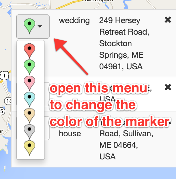
How can I change the color of the marker for an address?
You can change the color of the markers by adding the locations to the map, and then:

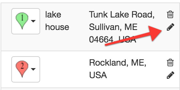
How can I edit locations in my map?
You can edit locations by first opening the map in edit mode (from My Maps). Then, find the location you want to edit in the right-hand listing, and click the pencil icon on the right:

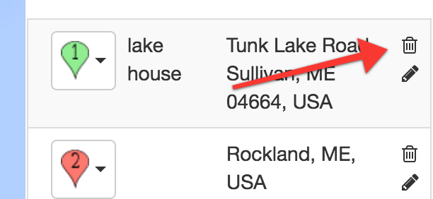
How can I remove locations in my map?
You can remove locations by first opening the map in edit mode (from My Maps). Then, find the location you want to remove in the right-hand listing, and click the trash can icon on the right:

How do I edit/delete a map that I created?
You can edit or delete maps that you create by going to the My Maps page. However, maps will only be saved to this listing if you a) are logged into the site, or b) are not logged in, and do not have Do Not Track enabled in your browser settings. If you have Do Not Track enabled (it is on by default in some browsers), then my site will respect that, and will not associate any actions you take on the site with your computer.
If you did create a map while you were not logged in and had Do Not Track enabled, and it has private information on it, please let me know the link to it, and I can remove it for you.
Do I need to log in to create a map?
You don't need to log in or create an account to create a map and share it with your friends or colleagues. You can just go to the homepage and create a map. Normally, any maps that you create when logged out will be associated to your computer and browser using a 'cookie'. This will let you edit or delete any maps that you create, as long as you are using the same computer and browser. If you then log in or create an account, these maps will be transferred to your account.
However, if you have Do Not Track enabled in your browser, (it is on by default in some browsers), then my site will respect that, and will not associate any actions you take on the site with your computer. There will be no cookie associating your maps with your browser, so you will not be able to edit or delete the maps after they are created.
If you did create a map while you were not logged in and had Do Not Track enabled, and it has private information on it, please let me know the link to it, and I can remove it for you.
Viewing Maps
Why can't I find the map that I created in the 'My Maps' listing?
The most likely reason that the map was not automatically associated with your account when you logged in was that you have Do Not Track enabled in your browser (it is enabled by default in some browsers). My site will obey that request, and will not associate any actions that you take with anything that can be identified to you. (Unless you are logged in to the site, which I interpret as a stronger signal that you in fact do want your maps to be saved to your account.)
If you did create a map while you were not logged in and had Do Not Track enabled, and it has private information on it, please let me know the link to it, and I can remove it for you.
Who can view maps that I create?
Any map created on my site will be viewable to anyone with the address. This site does not publish an index of all the maps, so if you create a map with an obscure name (or let the system generate a random name), and then never share that link, it is unlikely that someone will stumble on it (but not impossible). If you do share the link, then anyone who gets it will be able to view the map.
General Questions
Can I embed a map on my own website?
Embedding is not supported, but it is a feature that I am considering adding as part of a 'premium' service of the site. In the meantime, you can always create a map and link to it from your site (this functionality will always remain free).
How do I print a map?
To print a map, you can use your browser's built-in print functionality. You may need to adjust the zoom level and/or move the map a bit to ensure all of the locations are visible (because printer paper and computer screens are generally a different shape). You can use the print preview feature to help with this, so you don't have to waste paper. You can also use the print-to-PDF functionality if you want a PDF copy of it.
How do I export a PDF of a map?
It isn't currently possible to export a map as GPX, KML, or other formats. I may add this functionality in the future, but for now, you can create a PDF file of your map for offline use.
You can create a PDF from the map by using your browser's built-in print function, and saving to PDF (you might need to adjust the zoom level or move the map to make sure all of the locations fit, since printer paper and computer screens are generally different shapes--you can use print preview to test it out until you get it right). You can also share the map using the URL generated while saving or by clicking on the pinterest or facebook icons.
Can I download a map that I create?
You can create a PDF from the map by using your browser's built-in print function, and saving to PDF (you might need to adjust the zoom level or move the map to make sure all of the locations fit, since printer paper and computer screens are generally different shapes--you can use print preview to test it out until you get it right). You can also share the map using the URL generated while saving or by clicking on the pinterest or facebook icons.